AI-Powered Infrastructure Inspection: How Drones and Digital Twins Improve Asset Management
AI-powered infrastructure inspection combines drone data collection, automated analysis, and digital twin asset management to give asset owners faster, safer, and more consistent condition records. Instead of treating each inspection as an isolated visit, teams can compare repeatable 2D and 3D datasets over time, locate changes, and prioritize engineering review or maintenance.
Problems with Traditional Inspection
Conventional inspection often requires workers to climb structures, enter difficult terrain, stop equipment, or use access platforms. These methods can be slow, expose personnel to hazards, and produce photographs or notes that are difficult to compare across inspection cycles. Drones can support bridge and infrastructure inspections by collecting detailed imagery and sensor data from elevated or hard-to-reach areas.
How AI Drone Infrastructure Inspection Works
A drone infrastructure inspection begins with planned flight routes and suitable imaging sensors. The aircraft collects overlapping images or other sensor data around the asset. Photogrammetry then converts the imagery into orthomosaics, point clouds, or 3D models, while AI can flag selected visual patterns, objects, or changes for human review.
A digital twin connects this spatial model with asset attributes, maintenance records, and, where available, IoT data. Repeated surveys update the record, allowing engineers to compare current conditions with earlier inspections. The result is not an automatic replacement for hands-on testing or nondestructive evaluation, but a structured evidence layer that helps specialists decide where closer inspection is needed.
What Are the Benefits of AI Infrastructure Inspection?
Faster Inspection
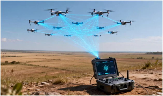
Drones can cover wide, elevated, or linear assets without moving crews through every location. Multi-aircraft coordination can further increase coverage. Icecypress Technology states that its BeeSmart system can allocate tasks and plan routes for more than 30 drones within one minute, subject to the project configuration and operating environment.
Reduced Risk
Remote data collection limits the time personnel spend at height, beside traffic, or near unstable ground. Unmanned aircraft can support bridge inspections, high-mast inspections, mapping, and disaster response while reducing the time personnel spend in hazardous locations. Qualified personnel must still supervise flight and engineering decisions.
Accurate 3D Records
Consistent image capture creates measurable records that can be revisited after the field team leaves. BeeSmart uses an onboard AI unit rated at 275 TOPS or higher and can generate 2D and 3D models and digital orthophoto maps during flight. Its official page lists centimeter-level mapping output and at least 95% change-detection accuracy.
Predictive Maintenance
Digital twins become more useful when new inspection data is added on a repeatable schedule. Teams can track deformation, vegetation encroachment, surface changes, equipment status, or recurring defects. When these records are combined with sensor readings and maintenance history, asset managers can move from fixed schedules toward condition-based maintenance and better-targeted interventions.
Where Can AI Drone Inspection Be Applied?
Common applications include bridges and transport corridors, transmission lines, oil and gas pipelines, water facilities, mines, industrial sites, and large construction projects. IceCypress also presents BeeSmart for energy inspection with infrared and visible-light payloads, while its pipeline solution combines UAV patrols, 3D modeling, AI recognition, and digital twin analysis for anomaly positioning.
Building a More Usable Asset Record
Effective AI infrastructure inspection depends on suitable sensors, repeatable flight plans, verified outputs, and qualified interpretation. BeeSmart can support large-area collection, onboard processing, and change analysis, while the wider IceCypress platform connects spatial data with operational workflows. For asset owners, the main value is a clearer, traceable record that supports safer inspection planning and more informed maintenance decisions.
#2 What Is Spatial Intelligence? How AI and 3D Data Are Transforming Industries
Spatial intelligence enables digital systems to perceive, reconstruct, analyze, and interpret physical environments in three dimensions. It connects location with geometry, relationships, and operational context. By combining UAV imagery, 3D models, artificial intelligence, and digital twins, organizations can turn spatial data into information for planning, monitoring, inspection, and risk management.

What Is Spatial Intelligence?
Traditional maps show where roads, buildings, pipelines, or terrain features are located. Spatial intelligence goes further by helping software understand how objects are shaped, how they relate to their surroundings, and how conditions change over time.
Outputs may include point clouds, textured 3D models, orthomosaics, detected anomalies, or updated digital twins. These results help specialists compare survey dates and focus on areas requiring investigation.
Spatial Intelligence vs. Traditional GIS
Geographic information systems remain a foundation for storing, querying, and displaying location-based data. Conventional GIS workflows, however, often depend on prepared layers and periodic updates.
Spatial intelligence solutions extend that foundation with automated data capture, 3D reconstruction, and AI-based interpretation. GIS may answer where an asset is located, while spatial intelligence can also help determine what surrounds it, what has changed, and which condition may require action. The approaches are complementary.
How Do Spatial Intelligence Solutions Work?
A typical workflow follows four connected stages that turn raw observations into a usable representation of the physical environment. Icecypress Technology describes this process as capture, reconstruction, and analysis, with digital twins providing a persistent environment for applying the results.
UAV Data Acquisition
Drones capture overlapping aerial images across cities, industrial facilities, mines, forests, pipelines, or disaster sites. Flight planning supports repeatable collection from elevated or difficult-to-access environments. Multi-UAV coordination can also divide large areas into separate tasks and combine the collected results.
3D Reconstruction
Photogrammetry software identifies matching features across images and calculates their spatial positions. Processing can produce point clouds, meshes, elevation models, orthophotos, and 3D scenes for measurement and visualization. Icecypress Technology’s Mirauge3D supports UAV images, aerial photographs, satellite images, LiDAR point clouds, and other data sources.
AI Analysis
AI models add semantic information to reconstructed geometry. Depending on the model and input quality, they can classify objects, detect selected anomalies, locate targets, or compare surveys for visible changes. Human review remains necessary when results influence engineering or safety decisions.
Digital Twin
A digital twin connects the spatial model with operational records, sensor data, asset attributes, or inspection history. Unlike a static 3D visualization, it can be updated as the physical site changes, supporting monitoring and lifecycle management.
Where Is Spatial Intelligence Applied?
Infrastructure and Energy
Spatial data can support pipeline patrols, utility inspection, construction monitoring, and asset documentation. Repeated UAV surveys help teams maintain visual records and identify changes across large areas.
Smart Cities and Natural Resources
Cities can use 3D environments for planning, facility inspection, water management, and land-use monitoring. Similar methods support forests, mines, rivers, and other changing environments.
Emergency Response
Rapid mapping can provide an updated view after fires, floods, landslides, or structural incidents. Three-dimensional scene information helps teams understand access routes, obstacles, and affected areas before deploying resources.
How Icecypress Technology Supports Spatial Intelligence
Icecypress Technology presents a capture-reconstruct-analyze workflow combining multi-UAV collection, 3D reconstruction, and spatial AI. Its ecosystem includes DroneSwarm for collaborative aerial collection and onboard analysis, Mirauge3D for large-scale 3D modeling, and systems for rapid reconstruction and target analytics.
These technologies are positioned for infrastructure, emergency response, municipal management, mining, and low-altitude operations. Their value lies in connecting raw imagery with measurable models and structured analysis.
The Future of Spatial Intelligence
Future systems will increasingly combine frequent updates, edge processing, cloud platforms, IoT feeds, and AI models. Progress will also depend on data quality, interoperability, cybersecurity, model validation, and human oversight.
As these foundations improve, spatial intelligence can help industries maintain current digital records, evaluate change sooner, and coordinate decisions across complex physical environments.